When you want to digitize from an air photo or remote sensed image, it must first be georeferenced so that it can be placed in […]
Continue reading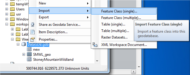
How to Import Shapefiles into a Geodatabase
Right click the File GeoDatabase > Import > FeatureClass (note: you can also import multiple FeatureClasses) Input feature: Navigate to the folder where the shapefile […]
Continue reading
How to Add a Toolbar
Open ArcMap > Click Customize > Click Toolbars. Notice that there are very many different tool bars in this list that can be added. If […]
Continue reading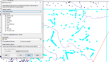
How to Select Data by Location in a Selected Zone
Under “Selection”, click Select by Location. For target layers, pick the layer you would like to have selected. Make sure that a location zone in […]
Continue readingHow to Edit an Attribute Table
Make sure editing is turned on for the layer you want to edit. Right click the layer, Open Attribute Table Simply click the field you […]
Continue readingHow to Turn on Editing
When you need to edit a feature make sure it is turned on and visible in your table of contents. Right click the layer you […]
Continue readingHow to Change Data Draw Order
Examine data order in the table of contents on the left. Notice what layers are above and below the other layers. These layers draw on […]
Continue readingHow to Add Data
Open the Catalog window, click the plus sign beside Folder Connections Click the folder where your data is stored. Drag it onto the work space […]
Continue reading
How to Turn on Labeling
Right the layer you want to have labeled on screen. In the dropout menu, click properties. A layer “properties window” opens, select the Labels tab. […]
Continue reading
How to Make a Mask
For Lab #3 – Cartography, students will need to make a mask to cover parts of the Alberta Land-Use Framework integrated regional plan. This mask […]
Continue reading